
CPRE's map presents information about light pollution and dark skies across England.
lightpollutionmap
Explore light pollution estimates, Bortle classes, and dark-sky locations on an interactive map.
About lightpollutionmap
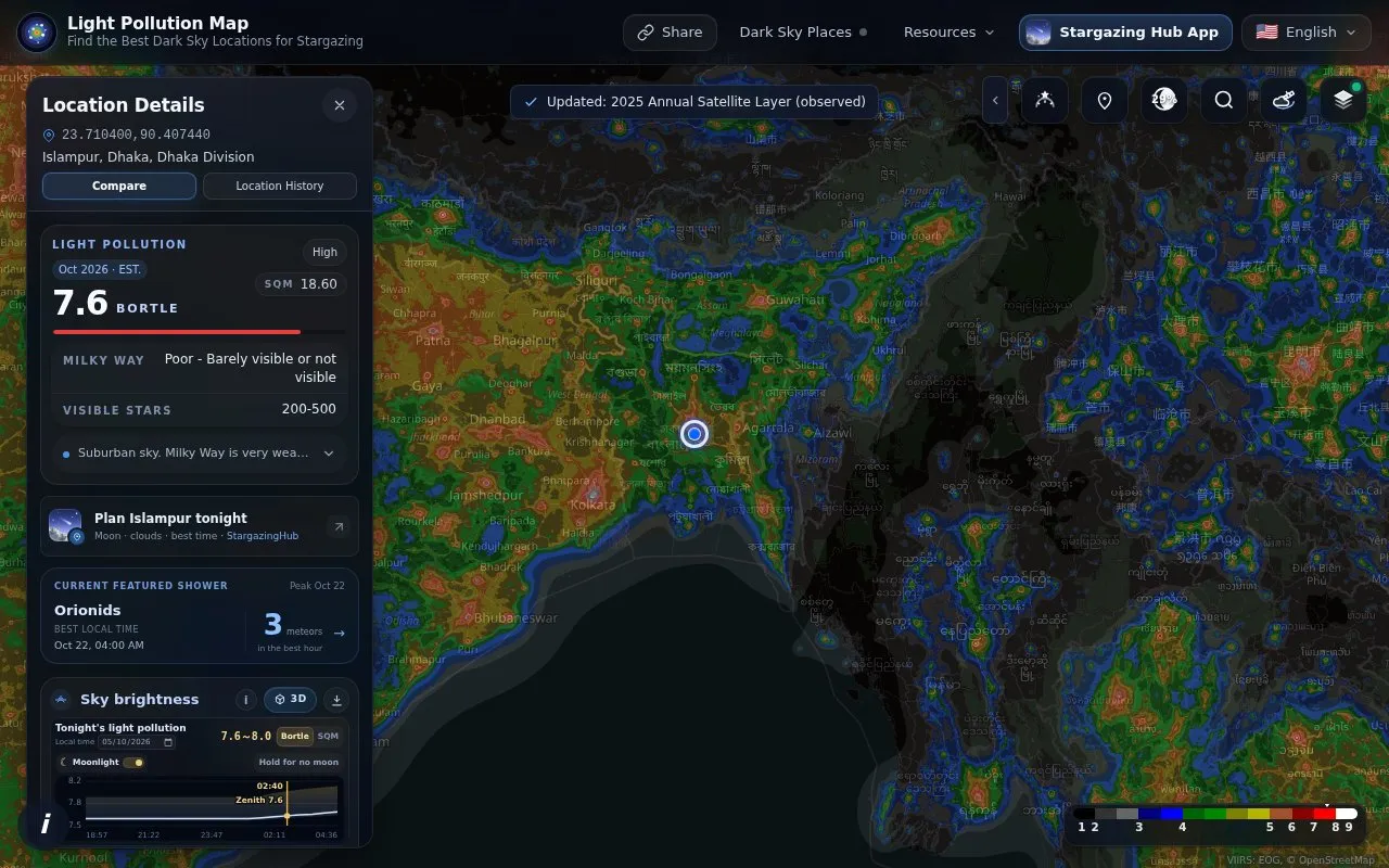
Light Pollution Map is an interactive map for checking light pollution estimates and dark-sky conditions. It shows 2026 estimates alongside annual satellite layers from 2012 to 2025, with Bortle class and SQM values for selected locations.
You can search for a location or click the map to see details such as Bortle, SQM, Milky Way visibility, and visible stars. The map includes controls for base maps, layer styles and opacity, day/night terminator, cloud and rain overlays, aurora probability, and certified dark-sky places. It also provides sky brightness views, nighttime weather, meteor shower forecasts, light pollution trends, stargazing spot search, and a sky photo analyzer.
It suits stargazers, astrophotographers, and travelers looking for darker skies who want to compare locations and plan observing nights.
Key features
- Search locations and click map for Bortle and SQM details
- Annual satellite light pollution layers from 2012 to 2025
- Certified dark-sky places overlay on interactive map
- Day/night terminator with clouds, rain and aurora overlays
- Stargazing spot search with radius and filtering options
- Sky photo analyzer for estimating sky brightness
Best for: People planning stargazing or night photography who need to compare sky darkness by location.
Good for
- Covers any location with searchable map
- Multiple years of satellite layers for comparison
- Combines sky, weather and aurora information in one view
Watch out for
- Values are approximations, not on-site SQM measurements
- Aurora probability feature is labeled as beta
lightpollutionmap at a glance
- Website
- lightpollutionmap.app
- Category
- Travel & Maps › Maps, Navigation & Weather
- Type
- Website
- Pricing
- Not confirmed. Check the site
- Platforms
- Android, iOS, Web
- Open source
- Not stated
- Language
- English
- Last checked
- Oct 5, 2026 · Online when checked
- Listed
- Oct 5, 2026
lightpollutionmap alternatives
Tools and sites you could use instead, ranked by how closely they match.

Light Pollution Map uses NASA data to display global light pollution and sky brightness layers.
The Digital Atlas of the Roman Empire lets users explore places and terrain through an interactive historical map.

Soar provides interactive and historical maps for users to explore and download.

MapCrunch opens a random Street View location that users can explore and share.

Snap Map lets users explore stories and locations from Snapchat on a desktop.
Popular in Maps, Navigation & Weather
Well-known listings from the same topic.
OpenWeatherMapopenweathermap.org511on.ca511on.caFIRMSfirms.modaps.eosdis.nasa.gov/mapWeather History & Data Archivewunderground.com/historyORBISorbis.stanford.eduEarth Engine Datasetdevelopers.google.com/earth-engine/datasets


lightpollutionmap FAQ
What does Light Pollution Map show?
It shows light pollution estimates with Bortle class, SQM, Milky Way visibility, and visible stars for a selected location.
How do I check light pollution for a location?
Search for a location or click on the map to open location details for that point.
Does it show dark-sky locations?
Yes, the map can display certified dark-sky places as an overlay.
What time periods are available?
It lists annual satellite layers from 2012 to 2025, plus 2026 estimates and trend data from 2006 to 2025.
Is something wrong or out of date?
Tell us and an editor will check it.
Own this website?
Claim this listing
Claim the listing and suggest updates yourself. An editor checks every claim first.